Introduction: The Davidization of Jerusalem
Visualizing Ideological Shift(s): From the Dome of the Rock/Western Wall to the Tower of David
Tracing Icons in (and of) Jerusalem
Referencing the Tower of David
Circulating Images of the Tower of David
Conclusions
Introduction: The Davidization of Jerusalem
Jerusalem has been the object of various gazes throughout centuries and millennia, and an essential stopping point in itineraries of the Holy Land. Appearing as a metonym of the Holy Land and also of the divine—Jerusalem and its visual icons have come to play a role in both religious practices and images, and more recently, in related political struggles over the control of simultaneously the physical area and its visual-symbolic representations.1 This paper focuses on what we see as a recent turning point in Jerusalem’s history of iconic representations, which is highly ideological and which is mobilized by a current synergy of ethno-national (Zionist) and neoliberal (or ‘free market’) economic policies that act in tandem to promote Israeli Jewish demographic and spatial dominance in Jerusalem. As the other articles in this issue attest, this turning point is situated amid a lineage of pilgrims’ and tourists’ experiences of the Holy Land that have historically been shaped by prior itineraries, travelogues, and souvenirs (including images). What characterizes the present shift is the state’s strong role in shaping the experiences and expectations of travelers in light of current political struggles, and its attempt to likewise mold the ideological perspectives of foreigners and locals alike through interventions in the representation of Jerusalem.
In order to trace – theorize and illustrate – current shifts, we need to briefly recapture a few relevant and recent historical points concerning the management of Jerusalem and its highly charged visualizations.2 Since 1948, Jerusalem has served as Israel’s administrative and symbolic capital, although the city was divided by an armistice line that relegated the Old City and the Jewish holy sites to Jordanian East Jerusalem. Israel’s annexation of East Jerusalem in June 1967, particularly its incorporation of the symbolic center of the Old City into the capital of the Jewish state, provided the impetus to fuse religious and political orientations.3 The Jewish dream of return was enacted through a government policy of occupation, resulting in a tense interplay between religious and national ideologies.
Since the 1990s Israel has pursued a policy of neo-liberal restructuring that has accelerated in the post-Oslo era, with the regress of the peace process between Israel and Palestine.4 As part of Israel’s concurrent integration into the global economic system, Jerusalem has at the same time increasingly appealed to foreign investment, promoting an imaginary directed at wealthy, ideologically-motivated diaspora Jews, and Israeli and foreign visitors to the city. Simultaneously, the transition from a secular to a religious and nationalist agenda in the municipality has resulted in the gradual change of Jerusalem’s symbolic value from an administrative capital (where religious and traditional symbolism assumed a background role) to a cornerstone of Jewish ethno-national identification. Enacting the myth of homogeneity that is the basis of the nation-state, Israel is pursuing a strategy of Judaization that is based on an exclusionary Israeli-Jewish national identity. Oren Yiftachel and Haim Yacobi term the establishment of hierarchical ethnic citizenship on the municipal level “urban ethnocracy.”5
Accompanying this turning point is a shift in the spatial and visual regimes of, and perspectives in, Jerusalem. We argue that a major and ongoing transition is taking place, from portraying the city for decades via the Muslim structure of the Dome of the Rock and the adjacent Jewish holy site of the Western Wall—to framing it as an exclusively Jewish Israeli city, with its focus on the Tower of David as the new icon. We refer to this change as the “davidization” of Jerusalem. We further contend that this shift powerfully combines ethno-national policies, which revolve around the notion of the exclusively Jewish state, on the one hand, and neo-liberal policies, which revolve around an economic restructuring of Jerusalem, on the other. To support our proposition we present in this paper a semiotic analysis of two types of data in the shape of, first, recent architectural sites and structures that make reference to the Tower of David or to the biblical King David, and second, municipal street posters and high-profile real-estate ads, and other spatial and visual ephemera that exemplify this historic and consequential shift. We argue that the Tower of David does not merely replace the old icons as ‘a new representation’ of a changing reality; rather, following Baudrillard6 we maintain that this icon no longer operates in the realm of representation but rather that it is implicated in the simulation of a new reality.7 The circulation of Tower of David images in the urban landscape and on everyday objects, and the multiplication of actual sites containing the name David constitute a cycle whereby image and reality are no longer separate, but where one begets the other. This process forges a new matrix that orients the gaze of visitors, long-time sojourners and locals alike towards the solitary Citadel (wherein the Tower of David is located) at the western entrance to the Old City.
BACK
Visualizing Ideological Shift(s): From the Dome of the Rock/Western Wall to the Tower of David
Jerusalem’s ethno-national divisions stem from a power struggle between unequally positioned actors. Since the 1948 Arab-Israeli War, which resulted in Israel’s independence and the destruction of Palestinian society, known as the Nakba, or catastrophe, Jerusalem has been a divided city. In 1948-67, East Jerusalem was in Jordanian territory while Israel controlled West Jerusalem, and the dividing border known as the Green Line was fortified in different stages and patrolled by soldiers on both sides. This barrier was dismantled following the 1967 War when Israel occupied the West Bank and annexed East Jerusalem, and incorporated its residents into the city’s municipality—a move defined by UN Resolution 242 as illegal, and by Israel as the unification of its ‘eternal capital.’
One of the central issues in the conflict over Jerusalem is the Old City, where the holy places of the Jewish prayer site of the Western Wall (ha-Kotel ha Ma‘aravi), often referred to as the Wailing Wall, and the Muslim Noble Sanctuary (al-Ḥaram ash-Sharif, whereupon is the golden Dome of the Rock) are adjacently located, forming a bone of contention for Israel and the Palestinians. The city’s overall population currently numbers 773,000 with Palestinians constituting just over one-third of it at 275,900.8 Jerusalem’s divisions are evinced in social and residential separation by ethno-national identity and exacerbated by differential allocation of municipal services, resources and funding to Israeli-Jewish and Palestinian-Arab sectors.9 Moreover, while Jerusalem remains an overall poor city, demographically Palestinians experience the most poverty.10 Following the failed Oslo peace accords of the 1990s, Israel continues to accelerate measures taken since 1967 to Judaize the city and reduce its Palestinians population, including settlement building in East Jerusalem and the construction of the Israel-West Bank barrier—which removed large Arab areas from the city—to maintain a 70% Jewish majority therein.11
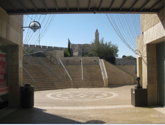
Since the second Palestinian Intifada (uprising) of 2000, also termed the al-Aqsa Intifada, there has been a shift in the Israeli establishment of its visual representation of the disputed capital – namely its emblematic sites – from the Dome of the Rock and the Kotel as the icons of Jerusalem, situated between the Muslim and Jewish Quarters of the Old City, to the Citadel and especially the so-called Migdal David (Tower of David), a first century BCE tower. It is one of three towers which were built or fortified by King Herod around 37–34 BC and the only one that remains.12 Since the beginning of the British Mandate in Palestine, the Citadel had ceased to function as a defense structure, and its impressive grounds were transformed into a museum. In this capacity it functions today, presenting information, exhibits, and performances dealing with the history of the city.13 The Citadel and the tower within it are located inside the Old City beside Jaffa Gate, the western-facing entrance named after its orientation to the port city of Jaffa. Bahat notes that “Today, erroneously, the name ‘David’s Tower’ refers to the seventeenth [century] minaret of the Citadel.”14 We therefore likewise refer to the Tower of David as the minaret as it appears atop the west-facing wall of Citadel in the images we analyze.
The shift from presenting the Kotel and the Dome of the Rock as the ‘stars’ in a repertoire of images that also included the Citadel (as well as other political and cultural landmarks like the Israeli Knesset)—to the Tower as the singular emblem of Jerusalem represents an extension of a previous phase in the Israeli visualization of the city. While Israeli postcards depicted the Citadel before the 1967 War, as Semmerling shows, following Israel’s annexation of the Old City the Tower of David became associated with state power, as exemplified in a postcard where it is featured as the backdrop for an Israeli military procession.15 The theme of militarism was also carried over to postcards depicting the Western Wall, where soldiers are shown holding parades or praying.16
This turn of events represents a departure from the era when Mayor Teddy Kollek presided over the city (1965-1993),17 when the Dome of the Rock/Kotel constituted a primary symbol of it (See Fig. 1), at times in tandem with the Tower of David. Former Mayor Kollek held a traditional pragmatist Zionist ethos and occupied many areas in East Jerusalem. At the same time, unlike all subsequent mayors to date, he consistently tried to avoid the fundamentalist Judaization of dense Palestinian neighborhoods, which his successors accomplished by erecting Jewish settlements within them. Emblematic of the prominent visualization of Jerusalem until the 2000s is a song that Kollek requested that singer and songwriter Naomi Shemer write for the 1967 Israel Song Festival, held three weeks before the 1967 War in June.18 Entitled “Jerusalem of Gold,” its refrain is “Jerusalem of Gold, and of Copper and of Light / For all your songs I am a violin.” For many, the song resonates with the golden hue of sunset reflected on the limestone of the city, but more so with the romantic (and Orientalized) image of the golden Dome of the Rock. This symbol was featured prominently on Israeli postcards especially by Palphot, the main Israeli postcard producer.
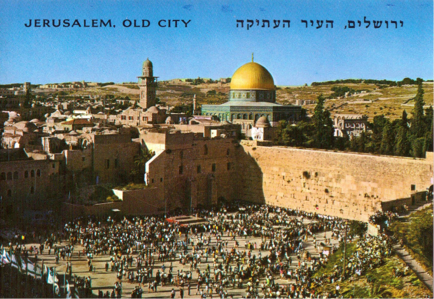
Fig. 1: Palphot postcard #9872 entitled ‘Jerusalem the Old City’ depicting the Dome of the Rock and the Kotel
Yet the three mayors who came after Kollek were explicitly right wing, and subscribed not to the socialist-national ideology of the center-left Mapai party,19 but to varieties of ethno-national policies and ideologies. As a result, and with the growing weight of Jewish religious discourse in politics,20 the value of Israel’s capital has gradually shifted from an administrative capital with a (mainly symbolic) religious and historic value to an embodiment of more Jewish ethno-national sentiments.
The second Palestinian Intifada also contributed to the shift away from the Dome of the Rock/Kotel to the Tower of David. The Intifada, and the subsequent escalation of terrorist attacks inside Israel, precipitated the construction of the Separation Barrier beginning in 2002 to control the entry of Palestinian West Bank residents into Israel purportedly for security purposes.21 The rise of a right-wing government, set on unilateral actions and disengagement from peace negotiations with the Palestinians, both stoked and corresponded to Israeli fears, fueling a cyclical justification of violence.
Lastly, the demise of the Mapai paradigm and the Intifada may be seen within a wider policy of neo-liberal restructuring pursued by the Israeli state since the early 1990s. As Clarno indicates, proponents of liberalization argued that the conflict posed an obstacle to Israel’s global economic integration, and considered peace negotiations with the Palestinians as a means to solve the state’s economic woes of the 1980s.22 Still, despite the absence of a resolution to the conflict with the Palestinians as evinced by the demise of the Oslo accords, Israel’s neo-liberal restructuring has proceeded without disruption, working by way of occupation rather than via negotiation. As part and parcel of Israel’s integration into the global economic system, Jerusalem’s real estate and tourism industries are conspicuous in their appeal to foreign investment. The city’s embrace of globalization is most evident in the building boom of luxury apartment complexes, hotels, and high-end retail establishments begun in the mid-2000s and which has since accelerated. Real estate construction and international tourism comprise two aspects of world city formation and propel the image-driven city by circulating images of luxury, convenience, and modernity.23
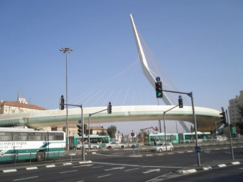
The connection between image-making, transnational movement and ethno-nationalism in Jerusalem is exemplified by two recently completed projects. The sleek Calatrava-designed ‘Chords Bridge’ that greets visitors at the western (main) entrance to the city, and the Jerusalem Lite Rail that travels on the bridge, play into a transnational imaginary of efficiency and smooth circulation.24 As we discuss below, the Chords Bridge references King David’s harp, thereby subtly announcing visitors’ entry into a Jewish-scape, while the bridge’s world-famous designer elevates the city’s symbolic capital. This imaginary is at odds with the controversies underlying the projects, due to the amount of money and time they took to complete, and because the Lite Rail traverses occupied East Jerusalem in its apparently seamless connectivity.25 This was the first light rail project in Israel as well as the country’s first experiment with private funding for a transit project,26 exemplifying another element of Jerusalem’s financial globalization. Although Jerusalem has been the conservative, poor, administrative foil to Israel’s liberal cultural and financial capital of Tel Aviv, Jerusalem nevertheless consistently pulls tourists because of its religious and symbolic significance.27
The tourism and real estate industries’ appeal to a foreign clientele—primarily affluent North American and French Jews—aligns with the municipality’s agenda of Judaizing the city in part through privately-funded ventures. This attention to foreigners has been contentious due to the ‘phantom apartments’ phenomenon—units purchased by diaspora Jews who visit Israel on occasion but which otherwise remain uninhabited. By flooding the housing market with their higher purchasing power and by keeping these units off the market from potential local renters, absentee owners have exacerbated the housing crisis in Jerusalem (which, of all the cities in Israel, has the largest percentage of real-estate purchases performed by non-Israeli investors).28 The summer 2011 protests, which brought thousands of Israelis to the streets, were sparked in part by the lack of affordable housing in the major cities. They have succeeded in prompting recent policy changes to make foreigners’ investments more difficult. Nevertheless, the real estate and tourism industries continue to cater to the transnational elites. The shift in the gaze from Dome of the Rock/Kotel to the Tower of David as the metonym presents Jerusalem as the eternal, unified ethno-national center, not only for Israeli Jews but also for the diaspora, and this is how Jerusalem from the 2000s is viewed.
BACK
Tracing Icons in (and of) Jerusalem
In the following we describe what we term the recent “davidization” in Jerusalem – the re-centering of the Zionist gaze on the Tower of David - one which selectively combines a new semantic field of Jerusalem as the City of David and as a global city. We conceive this as an exercise in theorizing ‘pertinent historicity’, that is, recovering what is relevant and not the entire history of the area. The structuring of the gaze that we believe is focused on the Tower of David in the Old City is accomplished through an inter-dispersed matrix of material and symbolic icons that populate the Jerusalem landscape, and which comprises its current davidization. In other words, there are multiple sites that help redirect and realign the gaze toward the Tower, and this occurs in two related processes that inform our analysis:
1) The appearance of actual sites that bear the name David (for instance, David’s Citadel Hotel), or make other semiotic references to King David (the Chords Bridge), or lead the gaze directly to the Tower of David (Alrov Mamilla Mall). This mushrooming of ‘Davids’ during the last decade occurs with the speed and multiplication of malignancies. Included in this multiplication are images of the Tower of David commonly found in public places (municipal and real estate ads) and movable objects that are frequently used (phone books, sugar packets).
2) These sites constitute a matrix that is falling into alignment with the shift of the gaze to the Tower; a new constellation that is revolving around a central axis. This is a relation between the many and the one. But these sites also exist in a relational grid: Each site is a node in Jerusalem whose placement is contextually significant, gaining meaning through its relationality to surrounding or nearby elements. The referencing becomes multi-directional and intensified as we get closer to the Tower itself, the state’s and the municipality’s new ideological center of gravity.
Our analysis is divided into two sections: The first describes a series of ‘David-ian’ sites following a trajectory from west to east, beginning with the Chords Bridge toward the architecture on King David Street and the Green Line, and ending with the City of David settlement and archaeological park to the south of the Old City. This trajectory is also a continuum that begins with global imagery (a sleek modern bridge bearing the new light rail) that reaches up to the sky, and ends with the ethno-national site of colonization, which is aggressively oriented to unearthing King David’s ancient city deep in the ground. The second section discusses the images of the Tower in print media, and relates their circulation to strategies of image-formation – accomplished through the banal and the everyday. This group of images is arguably more oriented to the local.
BACK
Referencing the Tower of David
The ‘Chords Bridge’
Following a west-east trajectory, the first prominent icon that visitors to Jerusalem see in what we call the ‘David constellation’ is the Jerusalem ‘Chords Bridge’ (Fig. 2a), inaugurated in 2008, whereon the Jerusalem Light Rail travels. Designed by famed Spanish architect Santiago Calatrava, the characteristically white structure is located at the main (western) entrance to Jerusalem, and its impressive aesthetic appearance consists of chords, which are presented as icons that evoke the image of the strings in David’s harp.29 Hence the bridge physically marks the entrance to the city of Jerusalem as an entrance to the biblical-scape (which is also an alluded biblical soundscape). Despite the biblical reference, however, it is not a regionalist architectural form; the bridge represents a departure from previous, state-supported building schemes in which Israeli architects employed neo-Oriental motifs and materials—such as arches, courtyards, and local limestone—to achieve an “active re-rooting” of contemporary Jewry into the landscape.30 The effect is therefore not of integration into the (biblical, even ‘Levantine’) landscape, for the bridge’s smooth form stands in sharp contrast to everything that is seen around and through it. At the same time, with its multi-dimensional reach, it catches everything in sight within its net; through technology and optics, the state is able to capture the entire city in what Handelman terms a bureaucratic aesthetics of the state.31 Moreover we can say that the global is imposed or transposed on the local. At the same time, a Calatrava-designed bridge has become a status symbol, a ‘must-have’ for world cities.32 The bridge’s high modernist style seems to announce Jerusalem as a global city while also making reference to a biblical past, fusing past and present through contemporary architecture. The Chords Bridge is a kind of screen that announces the matrix; we see the city through the lattice that it creates.
The Green Line Triangle
Inside the former Green Line lies the threshold to Jaffa Gate, leading to the Old City and the David Citadel within it. Here the gravitational pull is magnified as the distance between the sites is reduced: The King David Residence, David’s Citadel Hotel, and Alrov Mamilla, all on King David Street, form a triangle. It is worth noting that these structures draw on the cultural capital of the extremely well-known and high-scale King David Hotel, built in the 1920s and situated nearby on King David Street. Two additional David-ian sites are located in this vicinity: the Kfar David complex, and further to the southeast, the City of David. We address these sites in this order: first the three on King David Street, followed by the two others.
The King David Residence represents an instance of the Jerusalem municipality’s re-orientation agenda: it is part of the Judaization, and specifically davidization of city, combining normative and contested ideologies and spaces. It is therefore to be understood as carrying David’s sign (which is inscribing greater swaths of Jerusalem), including the aforementioned Chords Bridge. In this particular case, David is not only a sign of religious nationalism but also of luxury for a transnational Jewish diaspora (its website originally was in English and French, but not Hebrew). The building is a ten-minute walk from both downtown West Jerusalem and the Old City’s Jaffa Gate. Reminiscent of a tourist bubble, it is a particularly high-end complex of apartments, barred from the street’s commons by a secured lobby, guards, and surveillance equipment. The complex combines amenities for inhabitants of both elite and Orthodox Jewish populations: It includes three buildings with 88 luxurious apartments, commercial areas, a swimming pool, underground parking, an underground wine cellar, a synagogue and Shabbat elevator.
The building’s privatized lifestyle is accomplished through ‘indoorization.’ By indoorization, we refer to the mechanisms that serve to enclose the residents in a protected space while keeping out unwanted others, as well as to the ethos of privatization and individualization that signals the King David Residence as a separate universe, as opposed to an orientation towards the public space of the street.33 The complex’s securitization recalls the guards and cameras that often surround Jewish establishments abroad, and feeds into the Israeli narrative of persecution by a Palestinian (and more broadly, Muslim) Other,34 hence connecting transnational flows of wealth with state security apparatuses. Architecturally and ideologically, the building borrows from the citadel motif, conforming to the clientele’s triple desire for access to Jerusalem and its holy sites, a high-end lifestyle, and ‘security’. The Residence icon (its logo— see Fig. 2b) is in the shape of a harp, suggesting thus a David-related visual image which compliments the complex’s name. Indicative of globalization and convenience, the King David Residence exists in a topological conversation with high-end shopping and hotels located across the street in this triangle on the Green Line.
The second site we discuss in this section is the David’s Citadel Hotel (Fig. 2c), which is located right across the street (on King David Street) from the King David Residence, and it too is within a ten-minute walk from the Tower of David. It was the first of the three structures to be built, and here we are pointing out the name of the hotel and its façade – where the latter shows an interplay between openness and defense, echoing the notion of the citadel. Whereas the Chords Bridge relates to the space around it through transparency (enabled by open spaces between its strings), the façade of this hotel looks like a fortification that minimizes permeability; the open planes are filled in, in addition to being layered. Handelman wisely terms this ‘Third Temple’ architecture and situates the hotel in a matrix of bureaucratic aesthetics of the state.35 The façade of the hotel is a concrete slab faced with Jerusalem stone in the shape of tall arches. The arches reference the common shape for passageways or doorways in the Middle East, where they are indicative of shelter, hospitality, and protection. And yet the architecture of the front of the hotel tells us that this is a citadel.
The very tall aches announce a monumentality that is not as permeable as it may appear. The first line of defense is a soft boundary: trees are planted in the spaces of the arches; above them are smaller square-shaped openings that recall the openings in tall citadel ramparts where snipers would stand. Behind this arch is the crescent-shaped driveway, and further back stands the actual hotel with its tall windows. Notice the lattice-like effect of blue cross beams over the window. Viewed straight on, there is a feeling of depth and defense resulting from the juxtaposition of two lattices. From the main (Mamillah) junction nearby, the Tower of David can be seen further away, supplying the background for the presence of the David’s Citadel Hotel.
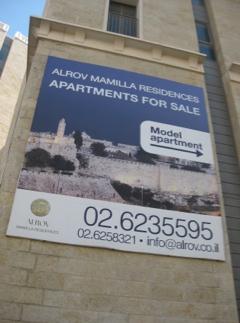
The third and last site we discuss is Alrov Mamilla, a high-end residential and commercial pedestrian strip (basically, a mall) completed in 2007.36 Built to traverse the former Green Line, this fortified walkway connects West Jerusalem to the Old City (in East Jerusalem), creating a sense of seamlessness across the old dividing line. The appeal of this complex to a global imaginary of high-end real estate is predicated on the illusion of unification between East and West Jerusalem through architecture. It aims to attract foreign Jewish tourists and buyers by erasing traces of division, thereby bolstering the economy of this traditionally poor city.
Until the city’s division in 1948, Mamillah’s location between the Old City and West Jerusalem contributed to its economic viability. It was a commercial and transportation hub that extended from Jaffa Gate, and included clothing shops and hotels, car dealerships and garages. During the Armistice Regime (1949-1967), it was relegated to No Man’s Land, and the area was largely abandoned owing to its proximity to the dangerous border. The new Alrov Mamilla, constructed as a shopping corridor, was built to connect Jaffa Gate to West Jerusalem’s traditional city center, the ‘triangle’ of King George, Jaffa and Ben Yehuda Streets. In serving as a kind of bridge between the Old City and the high-profile cluster of residential buildings and hotels along the intersection of King David Street and Agron Street, Alrov Mamilla successfully connects between a globalized future and the ancient past of the ‘City of David.’ It anticipates and partly enacts an enclosure of its own and is referential to the enclosure of the King David Residence. Fig. 2d shows the eastern emergence or exit from Alrov Mamilla’s shady walkway, which opens dramatically onto the very sunny image of the Tower of David. If the walkaway serves as a bridge that offers a high-end consumer connection between West and East Jerusalem, then its east-facing destination is set on the Tower of David.
The foregoing discussion indicates a new relationship between individual sites and the whole, reconstituting the entire city of Jerusalem as the City of David with its entrance in the west through the Chords Bridge and its counterpart in the Old City of the Tower of David within Jaffa Gate, whence the Holy Basin and the City of David archaeological park are reached. Understood as markers of a reconstituted biblical terrain, the sites may arguably become key symbols that evoke structures of feeling, namely of a spiritual ascent of pilgrimage or tourism.37 The final approach to the Tower through Alrov Mamilla is via an ascent, aliyah, such that ascending from the mall to the Tower of David constitutes a twist on the familiar scenario, now linking transnational travel and consumption with the new symbol of ‘unified’ Jerusalem.
Mamila Kfar David and the City of David National Park
Two final examples that support Jerusalem’s davidization are the Mamila Kfar David38 complex and the City of David National Park and settlement. Mamila Kfar David is a high-end, gated complex of luxurious apartments that was built during the 1990s, and which is located to the east of David’s Citadel Hotel and closer to the Jaffa Gate and the Tower of David (See Fig. 2e). Since it is mostly owned by foreign investors and by Jewish residents who visit Jerusalem only on High Holidays, the area is usually empty of people and devoid of social life, and has come to be called a “ghost neighborhood” (in Hebrew, shekhunat refa’im).39 The complex’s windows typically face the Tower of David. Since the complex was built relatively early, it is one of the first projects that established the view of the Tower as a high-end visual product.
The final example concerns the name and the logo of one of the more active Jewish settler organizations in East Jerusalem, namely the ElAd organization. ElAd, which is an acronym for “to the City of David” (El ‘ir David), is an Orthodox, right-wing settler organization whose main goal is to Judaize Palestinian East Jerusalem.40 Important for the present discussion is the fact that it is also in charge of an important Jewish heritage site—located in the Holy Basin, in proximity to al-Ḥaram ash-Sharif and the Western Wall—named the City of David National Park.41 ElAd’s logo is a golden harp, indexing, again, King David’s Harp and the fantasy of the revival of a Judean Kingdom.
The park is a highly visited heritage tourist site, although it is mainly visited by Israelis. The signs and the tours there narrate exclusively the Jewish ethno-national past, omitting anything having to do with the contemporary and archaeological presence of Palestinians and other cultures (despite the fact that the Park is located within a densely populated Palestinian part of town). The park employs its own security guards who walk around with guns, and there have been numerous altercations between them and Palestinian residents of Silwan. Also, of the dozens of national parks in Israel, it is singular in that this one is operated by private hands, and in that it has residents (in the shape of Jewish settlers) living within its confines. The point is that this site, which is located near and to the south of the Old City, also promotes the davidization or the reorientation of the conjoined spaces of both East and West Jerusalem.42 Its symbiotic relationship with the municipality exemplifies the way that privatization has opened the gates (so to speak) for the Judaization of East Jerusalem.
As indicated by this constellation of images and landmarks – from the global architecture of the Chords Bridge in the west to the nationalist settlers’ heritage park City of David in the east, the new focus is suggestive of an emergent visual and semantic field; of a network of sites related by the appellation David. In the next section we move from the matrix of structures to circulating images, which also have the iconic Tower of David as their visual focus.
BACK
Circulating Images of the Tower of David
We noted in the introduction that the gravitational and ideological power of the Tower of David icon derives from both the mushrooming of referential sites, which we highlighted in the previous section, and its circulation as an image in various media in spaces within Jerusalem and beyond. In this section we shift somewhat our object of analysis from actual sites that reference the Tower of David, to various contemporary widespread images of the same. Before we pursue this, however, we wish to interject a further discussion concerning the symbolism underlying the shift from the Dome of the Rock/Kotel to the Tower of David. Our point here concerns two aspects of the architecture and environment of the Western Wall that have partly propelled the shift away from it as a major iconic image. The first concerns the fact that the Wall is not highly visible: it is unobtrusive and despite its large size it is hidden and invisible when glossing Jerusalem’s – and even the Old City’s – skyline. Indeed, despite the holiness of the Western Wall, what became the most common image of Israel’s capital was the large and golden Dome of the Rock, which is located nearby and is highly visible, even eye-catching from both near and far. From the Zionist perspective, the problem with the Dome of the Rock as a metonym for the capital is that while it successfully indexed the adjacent Western Wall, it is a highly religious Muslim site. And, with the growing religious tensions and divides (the ongoing escalation of the Israeli-Palestinian conflict to religious terms) the Israeli state’s regime had to grapple with this attribution.
Furthermore, there are other important semiotic differences between the Dome of the Rock and the Tower of David, over and above the fact that the former is a Muslim site of worship. First, graphically, the Dome presents precisely that – a round and decorated (golden-covered) structure. In Zionism’s national imagery, the Dome of the Rock, as well as Jerusalem as a whole, enjoyed mostly feminine attributions and metaphors.43 In the military language of the 1967 War, Jerusalem was a passive and nearly hidden city, waiting to be stormed and rescued by Israeli paratroopers. In Naomi Shemer’s (aforementioned) famous song, which for years enjoyed the status of an informal national anthem, Jerusalem is portrayed as a gentle female image who is being sung to, praised, and perhaps courted (as in the famous verse “For all your songs I am a violin” [Le-kol shirayikh ani kinor], where ‘your’ is gendered as feminine). The passivity and femininity associated with the image of the city of Jerusalem (and its Old City) were further symbolically augmented by the fact that the Western Wall is a sign of Jewish defeat. This one is not merely a religion symbol, but it is also a remnant of one of the outer supporting walls of the Second Jewish Temple, and is therefore a symbol of the destruction of the Second Temple and of the suppression of Jewish rebellion by the Romans in the first and second centuries (specifically 70 CE).
Hence, the shift away from the Western Wall and from the round, feminine (i.e. passive) and Muslim Dome of the Rock, was also a shift to a site that was not collectively associated with Islam or with femininity. The Tower of David is not a round worship site or a relic of an ancient disaster or loss. To the contrary, it is a stern Herodian fortress whose associated minaret is visibly erect and standing sunny and bright (and phallic). In collective Zionist history it is not associated with defeat or disaster, and as a fortress it connotes defense and assertion. Also, it is not completely associated or even identified with religious symbols. Tunnel tours represent the Western Wall as a symbol of victimhood and hope for redemption, while the Tower is a phallic symbol.
Now we turn back to images of the Tower of David that suffuse the city with the ideology the state wants to permeate. We will present six images, though many others exist in the city’s spaces.
Municipality Street Posters
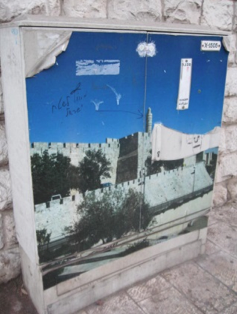
Taken in May 2010, Fig. 3a shows a poster on an electrical box, a common element in the urban topography of Jerusalem. The poster presents the familiar frontal image of the Tower, with the upper third showing blue sky (connoting Israel’s national blue-and-white flag). Graffiti appears on the poster. It reads in Hebrew, “Outside Israeli territory,” with an arrow pointing directly to the Tower of David. To the right of the Tower, part of the poster is peeled away (or ripped?), and in this gap an interesting and surprising figure is revealed – that of Kishkashta, a beloved puppet of a classic Israeli children’s show who is shaped like a cactus and symbolizes the sabra figure of the native Israeli. There is an interplay of symbolic elements here, suggesting that the top-down strategy of flooding the urban topography with ideologically-laden images does not escape local activists, nor does the fact that the Tower is a political and hence problematical icon. The image of Kishkashta, whether drawn before the image was ripped or after it, also stresses the tension between hegemonic and non-hegemonic discourses, and between naïve and mundane images, on the one hand, and phallic images of ethno-national pride, on the other hand.
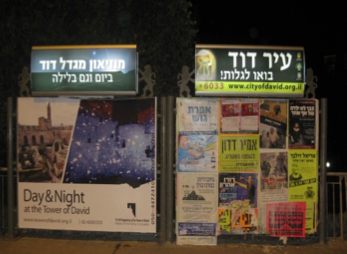
Standard municipal billboards present larger, detailed and obtrusive images of the Tower of David. The image in Fig. 3b was taken in the city’s center on January 2011, where it was present a few months before and a few months after it was taken, as well. The billboard on the left-hand side carries an illuminated sign that says in Hebrew “The Tower of David Museum: at Day and also at night.” The large poster below it presents two images of the Citadel’s inner courtyard with the Tower in the top center taken at daylight (left) and nighttime (right).44 Interestingly, the title of the illuminated sign above the billboard on the right-hand side is an ad for the City of David site (the text saying: “Come to discover!” and an image of the Harp on the left).
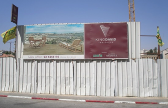
We mentioned earlier the Alrov Mamilla Project in its capacity as a site whose architecture structures shoppers’ and pedestrians’ view and tunnels it directly unto the David Tower. In addition, on the walkway’s west and south entrance walls, large real-estate advertisements are hanging, which also reference the Tower of David (See Fig. 3c). As of 2012-13, the large advertisements face the Mamillah junction, and are located five minutes from the actual Tower, such that the posters and the Tower can be seen simultaneously by the pedestrian. The point is that this representation exists not away from or in the place of the actual object, but rather as a marker which redefines its object, or as Baudrillard would have put it, it simulates the object. These ads suggest the Tower of David as a visual icon to be consumed – specifically through the purchasing of high-end apartments in this complex.
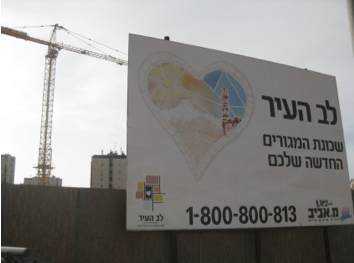
The Tower of David also stars on a number of large billboards announcing the ongoing construction of a large residential complex (of some six buildings and 330 apartments) that is located in West Jerusalem, between the neighborhoods of Beit Hakerem and Givat Mordechai. The project’s commercial title is “The Heart of the City” (Lev ha-‘Ir), and its visual logo is appropriately a heart, in which the sun is seen on the left side, and the Tower of David on the right side (See Fig. 3d). In addition, a smaller shape appears on the left, which is the familiar and unique white structure of the Heikhal ha-Sefer (Shrine of the Book, housing the Dead Sea Scrolls) located in Jerusalem (near the Israel Museum) and commonly associated with it. The effect here emerges as the visual logo corresponds with the verbal title, such that inside the colorful heart the “City” is to be found – iconically represented through the Tower of David.
Postal Service Album and Stamp
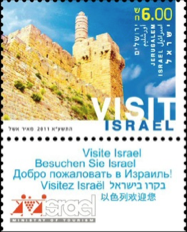
Stamp-collecting has been a popular pastime in Israel for several generations, and each year the Israeli Postal Service issues a series of new stamps and related collectables. A 2010 issue of a Jerusalem stamp album series is called ‘Jerusalem from Generation to Generation’—Prestige Booklet (Fig. 4a). The cover of the album displays three images emblematic of Jerusalem: The Kotel on the left, the Knesset on the right, and the Tower of David in the center. This Prestige Booklet costs 49 NIS (around 13 USD or 10 €). According to the description, “This booklet tells the story of the city of Jerusalem. It includes reprints of 11 previously issued stamps on the subject of Jerusalem. For technical reasons the stamps might be slightly different (size, color tone etc.) to the stamps originally issued in the past. Both sides of the cover have gold-foil printing.”47 Relatedly, a 2011 stamp bears a prominent, upward-looking view of the Tower (Fig. 4b). In his study of Israeli and Palestinian postcards, Semmerling states that postcards depict “national selves” through a range of carefully-composed images that include nationalistic, ecological, or heritage-infused symbols. Stamps function similarly as a ‘face’ of the nation-state.48 While some carefully choose the stamps they buy based on aesthetics or values, the transaction at the post office, where most Israelis purchase their stamps on an as-needed basis, is often swift and taken-for-granted. The Tower of David stamp thus circulates within and between plains of quotidian activity and symbolic representation.
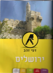
The image of the Tower of David appears on the cover of the two recent Telephone Yellow Pages books of Jerusalem (Fig. 4c). This is atypical, as during all previous years, and in other cities in Israel, the directory’s hard copy usually did not present symbolic-national images. While many nowadays prefer to search for phone numbers via the World Wide Web, and not the hard copy, it is worth noting that the printed directory is distributed freely and directly to all households in Jerusalem and the larger 02 area code – amounting to approximately 300,000 copies circulating annually. In this way, the frontal image of the Tower receives a high degree of visibility.
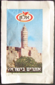
In June 2013 the first author of this article, on a visit to Jerusalem, went to a well-known café-restaurant called Tmol Shilshom. A Jerusalem establishment since 1994, it is owned and co-operated by David Erlich, a well-known and beloved figure. On the table beside salt and pepper shakers was a typical container of small packets of sugar and sweetener (Fig. 4d). The Elzan sugar packet that displays the Tower of David is part of a series of packets called “Landmarks in Israel.” The author’s companion remarked that this was a kind of trivia game; flipping the packet to the other side, one reads the name of the site followed by a description: “The fortress located on the highest place in the Old City, between the city walls and overlooking Ben-Hinom Valley, it was built by King Herod. [Located] in the strategic point that comprised a fortification throughout history with the aim of protecting the entire city from the west.”
This knowledge game recalls products such as gum wrappers and cigarette box cards commonly marketed to children, requiring them to purchase or trade the items to complete a series.
By permeating the materiality of the mundane, these images undergo a process of normalization, whereby they enter the realm of everyday activities (though as graffiti on the poster in Fig. 3a shows, never wholly without critique or backtalk). Note that in contrast to the sites we described in the previous section, these objects are more locally-inflected because they are either emplaced in an everyday and specifically Hebrew landscape that defines the borders of the nation state (as in the stamp album and the sugar packet series “Landmarks in Israel”) or they partake of mundane and functional activities (looking up a phone number, adding sugar to a hot drink in a restaurant or café), and hence are viewed by everyone, not only by the elite.
BACK
Conclusions
In this article we have argued that an ideological shift in the visualization of Jerusalem is taking place, one that corresponds to the re-orientation of the Israeli state’s economic and political agenda since the late 1990s and 2000s. The demise of the peace process saw a move towards right-wing politics, with far-reaching consequences for the contested city of Jerusalem. As we have indicated, since at least 1967 there has been a tradition of portraying the city via images of the Dome of the Rock/Kotel, indexing (from Israel’s point-of-view) the sometimes uncomfortable yet nevertheless taken-for-granted dynamic of Israelis and Palestinians living cheek-by-jowl in a city that is holy to the three monotheistic religions. The new visualization of Jerusalem via the icon of the Tower of David corresponds to the shift away from negotiations with the Palestinians and to erecting barriers to difference—in effect, to building a citadel in which the myth of ancient Jewish homogeneity reigns. Hence, the move from the dual image of the Dome of the Rock/Kotel to the singular Tower of David signifies for us the rise of an aggressive and fundamentalist ideology that seeks to deny Jerusalem’s non-Jewish or ‘with-Jewish’ pasts, and hence the possibility of imagining Jerusalem as a shared city. At the same time, the shifting representation also entails an attempt to (further) cement and legitimize Israel’s claim to the Old City – and to all of occupied Jerusalem, i.e. ‘unified Jerusalem’ – with regard to all future peace negotiations.
These legitimization processes, which also entail an erasure of the Green Line, in a way, work both domestically as well as vis-à-vis external audiences, visitors, and supporters. This aspect is part and parcel of the fundamentalist ideology to which we refer. The opening of the country to foreign capital—particularly to real estate investment by diaspora Jews both within the Green Line and in East Jerusalem—means that actual capital is mobilized in the visual consumption of the image of the Tower. The re-branding of Jerusalem as the ‘City of David’ is thus accomplished through a mutually-constitutive cycle of simulation and reality, whereby signs of the Tower (in Baudrillard’s terms, the map) and the actualization of Jewish ethnocracy (the territory) go hand-in-hand. The figure of the lone Tower as the emblem of Jerusalem constitutes a phase in the transformation of the image into simulation: By omitting signs of Palestinian presence, it “masks the absence of a profound reality”49 and paves the way for the simulation of a fiction of Jewish homogeneity. The Tower has become the object of a high-end visual consumer desire, where being able to see it instantiates the seer as authentically located in Jerusalem, and in its finest real-estate and touristic locations at that.
Importantly, our research is preliminary and so is our articulation of the disorienting shift in our experience of space in Jerusalem. We are naming a process that, as long-time (second author) and occasional (first author) residents of Jerusalem, we experience first-hand as affect, which we now attempt to theorize by working from the tangible to the ‘system’. Further historical and archival research would be needed to quantify this shift, to find antecedents of the current iconography in previous eras, circulations among prior groups, and more. In this vein, we have not been able thus far to obtain a statement – an explicit discourse emanating from the mayor’s office or the like – which addresses this process.
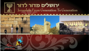
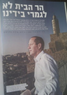
Rather, the ‘naturalization’ of this imaginary—how it became an obvious and natural element in contemporary visualization—is indicated in a recent supplement of the Israeli newspaper Haaretz, which appeared right before the last municipal elections in October 2013. The supplement’s front page shows Mayor Nir Barkat posing before the Tower of David, while the story page (Fig. 5) shows a slightly different angle of the same, with the title “The Temple Mount is not entirely in our hands.” These words refer to the historic saying “The Temple Mount is in our hands,” perhaps the most famous ‘catch-phrase’ of the 1967 War for Israelis. It was declared by General Motta Gur, who headed the 55th Paratrooper Brigade that “liberated” the Kotel. He announced this in the army’s telecommunication radio, and it is clear that he was aware of the historic nature of the moment and that he wanted to stamp it discursively (which he did successfully). The paraphrasing of this idiom in the aforementioned article addresses the fact that Mayor Barkat is running for elections and that his success is unsure. Saying the Temple Mount is still not ‘in our hands’ is the newspaper’s way of saying that the Mayor’s re-election is still not certain. What is essential here is the image, its recentness, and its role in elections, which suggest that the Tower of David is effective in the contemporary popular imagery and the current visual regime of Jerusalem associated with Mayor Barkat and Prime Minister Netanyahu. Moreover, the combination of the image and the caption evinces a discrepancy between the referent—the Temple Mount—and the new visual icon of the Old City, i.e. the Tower.
Through semiotic analysis (itself inspired by critical urban ethnography), we have sought to describe the city’s davidization bottom-up. Further, as we have indicated in the Introduction, Jerusalem has been, and still is the object of various gazes that compete, complement, and sometimes contradict and exclude one other (such a multiplicity of images appears in Fig. 4a). Mapping the entirety of this visual matrix is a project that far exceeds the present article’s scope, yet we traced what we argue to be a significant re-orientation in the hegemonic view of Jerusalem (from both ‘inside’ and ‘outside’, as it were).
On a final note, Dean MacCannell observes that walls help fundamentalists propagate the fiction that the past was free of difference.50 The davidization matrix is a simulation that acts like a wall. We might say that by occluding Palestinian presence, and by perpetuating the fiction-cum-reality of Jerusalem as an exclusively Jewish city, this matrix assists in the denial of interaction between different actors, an interaction that forms the basis of society.51 Crucially, however, the seamlessness of the imaginary contrasts with the reality that it can only be actualized by force, as ongoing struggles against forced evacuations in Palestinian neighborhoods like Sheikh Jarrah and Silwan attest. The simulation masks these urban battles but they constantly uncover its fictions, as graffiti on the poster.
BACK
Dana Hercbergs is a Visiting Assistant Professor at the Gildenhorn Institute for Israel Studies at the University of Maryland. Her research focuses on Arab and Jewish identities and encounters particularly in Jerusalem, and on their expressions in personal narratives, tourism, and urban forms.
Chaim Noy is an Associate Professor at the Department of Communication in the University of South Florida. His research focuses on performance approaches to tourism and everyday life, on language, discourse and social interaction, and on critical ethnographic methodologies.